

Jersey Airport Drone Disruption: What Happened, Why It Matters, and What Comes Next
ଜର୍ସି ବିମାନବନ୍ଦରରେ ଡ୍ରୋନ୍ ଯୋଗୁଁ ବ୍ୟାଘାତ: କ’ଣ ଘଟିଲା, ଏହା କାହିଁକି ଗୁରୁତ୍ୱପୂର୍ଣ୍ଣ ଏବଂ ଆଗକୁ କ’ଣ ହେବ? The Jersey Airport drone disruption was a two-night spell of unauthorised drone activity on 30 and

Global Mapper Subscription for Drone Mapping: Tiers, Features and Real-World Value
ଡ୍ରୋନ୍ ମ୍ୟାପିଂ ପାଇଁ ଗ୍ଲୋବାଲ୍ ମ୍ୟାପର୍ ସବସ୍କ୍ରିପସନ୍: ସ୍ତର, ବୈଶିଷ୍ଟ୍ୟ ଏବଂ ବାସ୍ତବ-ବିଶ୍ୱ ମୂଲ୍ୟ Quick answer: The Global Mapper subscription is the new annual, named-user licensing model from Blue Marble Geographics, offered in


FCC Counter-Drone Radar Rules: What the November 19 Vote Changes for Drone Detection and Communications
ଡ୍ରୋନ୍-ବିରୋଧୀ ରାଡାର୍ ସମ୍ବନ୍ଧୀୟ FCC ନିୟମ: ଡ୍ରୋନ୍ ଚିହ୍ନଟ ଏବଂ ଯୋଗାଯୋଗ କ୍ଷେତ୍ରରେ ନଭେମ୍ବର ୧୯ ତାରିଖର ଭୋଟ୍ କ’ଣ ପରିବର୍ତ୍ତନ ଆଣିବ? The short answer: On November 19, the Federal Communications Commission (FCC) is scheduled
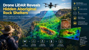
Drone LiDAR Reveals Hidden Aboriginal Rock Shelters in the Blue Mountains
ଡ୍ରୋନ୍ LiDAR ବ୍ଲୁ ମାଉଣ୍ଟେନ୍ସରେ ଆଦିବାସୀମାନଙ୍କ ଲୁକ୍କାୟିତ ପଥର ଆଶ୍ରୟସ୍ଥଳୀଗୁଡ଼ିକୁ ଉନ୍ମୋଚନ କରେ Drone LiDAR is a laser-based aerial mapping method that helps archaeologists locate rock shelters hidden under dense bushland. In the
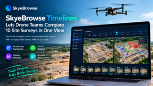
SkyeBrowse Timelines Lets Drone Teams Compare 10 Site Surveys in One View
SkyeBrowse Timelines is a new feature that places up to 10 drone surveys of the same site on a single date-based view, so teams can see what appeared, disappeared or

Prime Air Drone Delivery in Tallahassee: What Amazon’s Mid-November MK30 Launch Means for Residents
Amazon says Prime Air drone delivery will begin in Tallahassee, Florida, by mid-November 2026, carrying packages of up to 5 pounds (2.3 kilograms) from its Mahan Drive fulfillment center to