ଡ୍ରୋନ୍ LiDAR ବ୍ଲୁ ମାଉଣ୍ଟେନ୍ସରେ ଆଦିବାସୀମାନଙ୍କ ଲୁକ୍କାୟିତ ପଥର ଆଶ୍ରୟସ୍ଥଳୀଗୁଡ଼ିକୁ ଉନ୍ମୋଚନ କରେ
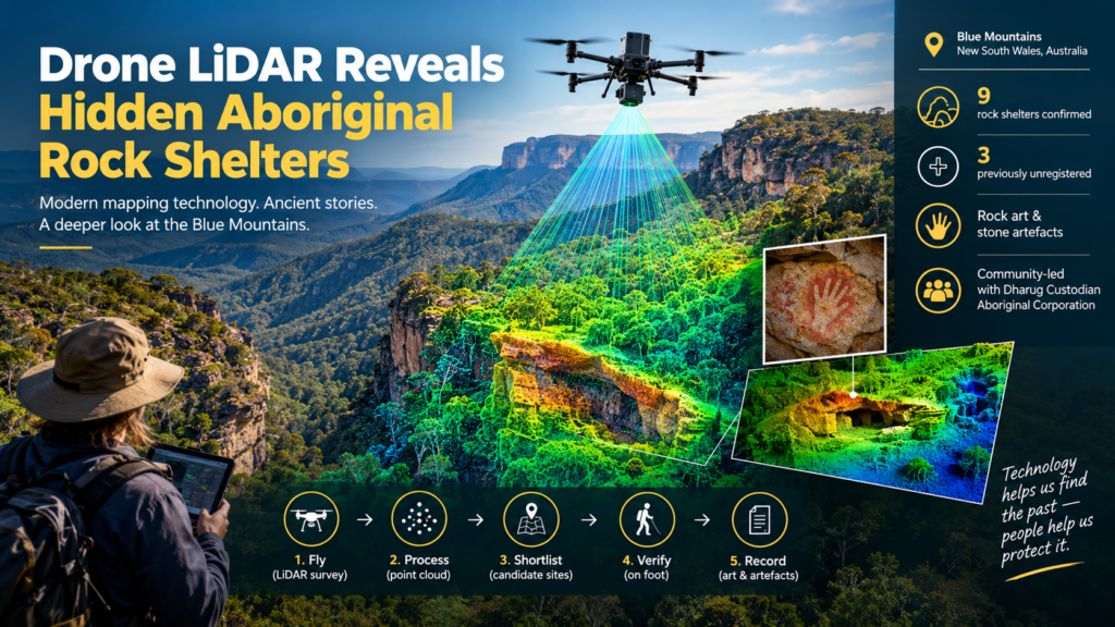
Drone LiDAR is a laser-based aerial mapping method that helps archaeologists locate rock shelters hidden under dense bushland. In the Blue Mountains of New South Wales, it has just helped confirm nine Aboriginal sites, three of them previously unregistered. The drone-based field surveys confirmed six registered rock shelters and three previously unregistered shelters containing rock art and stone artefacts. The work shows that drone LiDAR can turn a near-impossible search of rugged sandstone country into a focused, community-guided field program. sydney
If you have ever tried to walk off-track through Blue Mountains scrub, you know the problem. Cliff lines, deep gullies and thick canopy hide almost everything. This article explains what the researchers did, how the technology works, why it matters for Aboriginal cultural heritage, and what it could mean for archaeology well beyond New South Wales.
Key Takeaways
- Researchers from the University of Sydney’s Vere Gordon Childe Centre and the Australian Museum identified three previously unregistered Aboriginal rock shelters. sydney
- Drone LiDAR flew first, and people followed. Ground teams then visited the flagged locations to verify them and record what was there.
- More than 200 rock shelters have been recorded in the Blue Mountains, yet an estimated 10 percent of the region has been surveyed. sydney
- The work also produced much more accurate coordinates than those in the official NSW Aboriginal heritage register (AHIMS). archaeology
- The research was community-led, in partnership with the Dharug Custodian Aboriginal Corporation.
- The results were published in Remote Sensing in 2026 and point toward similar surveys across Australia.
What Is Drone LiDAR and How Does It Work?
Drone LiDAR is a survey technique in which a laser scanner carried by an unmanned aircraft fires rapid pulses at the ground and measures how long each takes to bounce back. The name stands for light detection and ranging. LiDAR uses laser pulses to build detailed 3D maps of a landscape, which helps researchers detect features hidden beneath dense bushland and tree cover. australian
Think of it as a very fast, very precise tape measure. Each pulse returns a distance. Millions of those distances, combined with the aircraft’s position and orientation, form a “point cloud”: a dense 3D scatter of points describing everything the lasers touched.
How a drone LiDAR sensor sees through trees
A drone LiDAR sensor does not literally see through leaves. It exploits gaps in them. A single laser pulse can produce several returns. The first may bounce off the top of the canopy, a later one off a branch, and the last off the ground itself. Analysts classify the returns, strip away the vegetation, and keep the ground points. The result is a “bare earth” model that shows cliff edges, overhangs, benches and slopes that aerial photographs cannot reveal.
For archaeologists this matters because rock shelters are landform features. They sit beneath sandstone overhangs, along cliff lines and on ledges, exactly the places that photography and satellite imagery struggle to show under tree cover.
What Did the Blue Mountains Drone LiDAR Survey Find?
The survey confirmed nine rock shelters: six already on the register and three that were not. The shelters contain rock art and stone artefacts. The newly recorded shelters include visually striking rock art such as red hand stencils. sydneyaustralian
Here is the survey at a glance:
| Item | Detail |
|---|---|
| Location | Blue Mountains, New South Wales, Australia |
| Registered shelters confirmed | 6 |
| Previously unregistered shelters | 3 |
| Cultural material recorded | Rock art (including red hand stencils) and stone artefacts |
| Lead institutions | University of Sydney and the Australian Museum |
| Community partner | Dharug Custodian Aboriginal Corporation |
| Published in | Remote Sensing (2026) |
The three “new” shelters carry a nuance worth knowing. In AAP’s reporting, Wayne Brennan said the three unregistered shelters had been known to researchers after skilled bushwalkers spotted them, and that the technology confirmed they existed. That means the technology verified and precisely located the sites rather than finding something nobody had ever seen. Verification and accurate location are exactly what a heritage register needs. nit
The equipment behind the survey
The team flew a DJI M350 drone carrying a YellowScan Explorer version 2 LiDAR sensor. This is commercial survey hardware, not a one-off prototype. That matters for repeatability, because other teams can buy comparable systems and apply the same approach. sydney
Why the Blue Mountains Are So Hard to Survey
The Blue Mountains are hard to survey because the terrain is steep, heavily vegetated and often only reachable on foot. The numbers show the scale of the gap: more than 200 rock shelters with cultural and archaeological evidence have been recorded, yet only an estimated 10 percent of the region has been surveyed because of its rugged terrain. The region is also a UNESCO-listed landscape, so the stakes for documenting and protecting its heritage are high. sydney
Traditional ground survey means walking transects, scanning cliff lines and relying on luck and local knowledge. It works, but it is slow and physically demanding. Lead researcher Dr Jacob Bongers describes drone surveying as an efficient way to cover rugged areas that are usually too expensive or difficult to explore. nit
The Gulamada Project: Where Science and Culture Meet
The Gulamada Project is a University of Sydney heritage research initiative built on the idea of walking side by side, combining scientific and cultural knowledge. Its stated principle is to combine scientific and cultural knowledge to bolster conservation. In the Gulamada Project, drone LiDAR is a tool in service of that partnership, not the headline. portnews
The people matter as much as the machine:
- Wayne Brennan, First Nations mentor, rock art expert and project co-director, told AAP that Aboriginal people are driving the research, with a real stake rather than mere consultation. nit
- Dr Amy Mosig Way, project co-director and research archaeologist, led teams of students and volunteers into the field to verify the sites flagged by the drone surveys. archaeology
- Dr Jacob Bongers, a digital archaeologist, led the drone-based research.
- Wayne Brennan and Erin Wilkins of the Dharug Custodian Aboriginal Corporation led the rock art recording at confirmed sites. australian
The Australian Government’s First Nations Heritage Grants program supports the project. That funding pairs technology with Aboriginal leadership, which is what makes the approach credible to the communities whose heritage is being recorded. archaeology
From Point Cloud to Rock Shelter: The Workflow
The workflow runs in a clear sequence: plan, fly, process, shortlist, verify, record. The published paper holds the project-specific details. In general, a LiDAR-assisted heritage survey follows steps like these:
- Plan the drone LiDAR flight. Agree the survey area with custodians, check permissions, and set flight lines to suit the terrain.
- Fly and capture. The aircraft scans the landscape and logs millions of laser returns.
- Process the data. Analysts classify ground points and build a bare-earth terrain model.
- Shortlist candidate locations. Landforms that look like potential shelters, such as overhangs and cliff-line recesses, are flagged for inspection.
- Verify on foot. Teams walk to the flagged locations to confirm whether a shelter exists and whether it holds cultural material.
- Record with custodians. Rock art and artefacts are documented under the guidance of Aboriginal custodians, and accurate coordinates are lodged.
Step five is the one that keeps the method honest. The drone proposes, and people on the ground decide.
Drone LiDAR vs Traditional Survey Methods
Drone LiDAR is best understood as an addition to existing methods, not a replacement. The table below compares the main approaches in general terms.
| Method | Sees through canopy? | Covers rugged terrain? | Relative speed over large areas | Best use |
|---|---|---|---|---|
| Ground survey (walking) | Yes, in person | Limited by access and safety | Slow | Verification, recording, cultural knowledge |
| Aerial or satellite imagery | No | Yes | Fast | Context and land cover |
| Airborne LiDAR (crewed aircraft) | Partly, via ground returns | Yes | Fast but costly to commission | Regional mapping |
| Drone LiDAR | Partly, via ground returns | Yes | Fast for targeted areas | Targeted candidate detection |
In short, drone LiDAR narrows the search so that people on foot spend their time at the most promising locations. It does not replace the knowledge of custodians, and it cannot stand in for visiting, understanding and recording a site.
Frequently Asked Questions
Can drone LiDAR see through trees?
Not literally, but it can see between them. Laser pulses slip through gaps in the canopy, and software separates ground returns from vegetation returns. The result is a terrain model of the surface beneath the trees.
Did drone LiDAR find the rock art itself?
No. Drone LiDAR maps landforms, and people record the art. The drone identified candidate locations, and field teams then confirmed the shelters and documented the art and artefacts. Wayne Brennan and Erin Wilkins led the rock art recording at confirmed sites. australian
How accurate is the location data compared with the official register?
Researchers report that it is much more accurate than the legacy coordinates in AHIMS. The work produced much more accurate coordinates than those listed in the official NSW sites register. The methodology can also improve the accuracy of legacy site coordinates in cultural heritage databases. That is a practical benefit for anyone who manages land where sites exist. archaeologyaustralian
Will drone LiDAR work in other parts of Australia?
The researchers think it has potential well beyond the Blue Mountains. The results lay the groundwork for further LiDAR-assisted surveys across Australia in partnership with Aboriginal communities. The paper notes the method could help locate rock shelters in rugged landscapes within and potentially beyond Australia. Results will depend on local vegetation, terrain and geology, so each region will need its own testing. sydneyaustralian
Who owns the knowledge produced by LiDAR archaeology?
That is a decision for the custodians, and it should be settled before any flight. In the Gulamada Project, Aboriginal people are partners and decision-makers. Any LiDAR archaeology program that maps cultural sites should agree in advance who holds the data, who can see site locations, and how sensitive information is protected.Aboriginal rock shelters,Blue Mountains archaeology,Aboriginal cultural heritage,Drone LiDAR archaeology,Aboriginal rock shelters,Blue Mountains archaeology,Aboriginal cultural heritage,Drone LiDAR archaeology
Limits and Responsible Use of Drone LiDAR
Drone LiDAR is powerful but not magic, and responsible use means understanding its limits.
- It finds landforms, not meaning. A shelter-shaped recess is only a candidate until someone walks in and looks.
- Dense vegetation and steep slopes can degrade results. Fewer ground returns mean a less detailed terrain model.
- Site locations are sensitive. Precise coordinates for cultural sites can be misused, so data handling needs the same care as the sites themselves.
- Permissions and protocols come first. Working with traditional custodians is part of doing the science properly, not an add-on.
These cautions apply to all LiDAR archaeology, not just this project.
What This Means for Heritage Protection
Better maps lead to better protection, because you cannot manage what you cannot locate. With only an estimated tenth of the Blue Mountains surveyed, many cultural places may sit near tracks, fire trails or development without anyone knowing. Faster, more accurate detection helps land managers and communities decide where to look, where to take care and where to plan around.
There is a training and capacity benefit too. Brennan told AAP that Aboriginal people involved in the project are gaining training. Students also gain hands-on experience, which Dr Way described as one of the most rewarding aspects of the Gulamada Project. Skills built this way stay in the community and the field long after a single survey ends.
Finally, the approach is scalable. A method proven in one of Australia’s most difficult landscapes is a strong candidate for others, particularly where traditional survey is slow or expensive. Used well, drone LiDAR could help communities and researchers expand the record of cultural sites far more quickly than ground survey alone.
Conclusion: A Faster Way to Listen to the Landscape
The Blue Mountains survey shows that drone LiDAR works best when technology and cultural knowledge move together. The drone flagged places worth visiting. Custodians, archaeologists and students then did what no sensor can: they walked in, recorded the rock art and artefacts, and connected each site to the wider cultural landscape. As Wayne Brennan put it, no site stands in isolation.
If you work in heritage, land management or archaeology, the next step is straightforward. Start conversations with traditional custodians early, define data protocols before any flight, and treat the technology as a way to guide careful fieldwork rather than a shortcut around it. For readers following Blue Mountains archaeology, this study is likely the first of many.
ଡ୍ରୋନ୍ ଲାଇଡାର୍ (Drone LiDAR) ହେଉଛି ଲେଜର ଉପରେ ଆଧାରିତ ଏକ ଆକାଶମାର୍ଗୀ ମାନଚିତ୍ରଣ ପଦ୍ଧତି, ଯାହା ପ୍ରତ୍ନତତ୍ତ୍ୱବିତ୍ମାନଙ୍କୁ ଘନ ଜଙ୍ଗଲ କିମ୍ବା ବୁଦାଳିଆ ଅଞ୍ଚଳ ତଳେ ଲୁଚି ରହିଥିବା ପଥର ଆଶ୍ରୟସ୍ଥଳୀ (rock shelters) ଖୋଜି ବାହାର କରିବାରେ ସାହାଯ୍ୟ କରେ। ନ୍ୟୁ ସାଉଥ୍ ୱେଲ୍ସର ‘ବ୍ଲୁ ମାଉଣ୍ଟେନ୍ସ’ (Blue Mountains) ଅଞ୍ଚଳରେ, ଏହା ନଅଟି ଆଦିବାସୀ (Aboriginal) ସ୍ଥାନକୁ ଚିହ୍ନଟ କରିବାରେ ସାହାଯ୍ୟ କରିଛି, ଯେଉଁଥି ମଧ୍ୟରୁ ତିନୋଟି ପୂର୍ବରୁ କୌଣସି ସରକାରୀ ତାଲିକାରେ ପଞ୍ଜୀକୃତ ହୋଇନଥିଲା। ଡ୍ରୋନ୍ ମାଧ୍ୟମରେ କରାଯାଇଥିବା ଏହି ସର୍ବେକ୍ଷଣ ଦ୍ୱାରା ଛଅଟି ପୂର୍ବରୁ ପଞ୍ଜୀକୃତ ଏବଂ ତିନୋଟି ନୂତନ ପଥର ଆଶ୍ରୟସ୍ଥଳୀ ଚିହ୍ନଟ ହୋଇଛି, ଯେଉଁଠାରେ ପ୍ରାଚୀନ ଶୈଳଚିତ୍ର (rock art) ଏବଂ ପଥର ନିର୍ମିତ ସାମଗ୍ରୀ ଦେଖିବାକୁ ମିଳିଛି। ଏହି କାର୍ଯ୍ୟ ଦର୍ଶାଏ ଯେ, ଡ୍ରୋନ୍ ଲାଇଡାର୍ ବ୍ୟବହାର କରି ଦୁର୍ଗମ ବାଲୁକା ପଥର (sandstone) ଅଞ୍ଚଳରେ ଯେଉଁ ସନ୍ଧାନ କାର୍ଯ୍ୟ ପ୍ରାୟ ଅସମ୍ଭବ ମନେହେଉଥିଲା, ତାହାକୁ ଏକ ସୁନିର୍ଦ୍ଦିଷ୍ଟ ଏବଂ ସ୍ଥାନୀୟ ସମ୍ପ୍ରଦାୟଙ୍କ ସହଯୋଗରେ ପରିଚାଳିତ କାର୍ଯ୍ୟକ୍ରମରେ ପରିଣତ କରାଯାଇପାରିବ।
ଯଦି ଆପଣ କେବେ ‘ବ୍ଲୁ ମାଉଣ୍ଟେନ୍ସ’ର ବୁଦାଳିଆ ଅଞ୍ଚଳରେ ନିର୍ଦ୍ଦିଷ୍ଟ ରାସ୍ତା ବାହାରେ ଚାଲିବାକୁ ଚେଷ୍ଟା କରିଥାନ୍ତି, ତେବେ ଆପଣ ସେଠାକାର କଠିନ ପରିସ୍ଥିତି ବିଷୟରେ ଜାଣିଥିବେ। ଉଚ୍ଚ ପାହାଡ଼ିଆ କାନ୍ଥ (cliff lines), ଗଭୀର ଖାଲ ଏବଂ ଘନ ବୃକ୍ଷରାଜି ସବୁକିଛିକୁ ଲୁଚାଇ ରଖିଥାଏ। ଏହି ଲେଖାରେ ବର୍ଣ୍ଣନା କରାଯାଇଛି ଯେ ଗବେଷକମାନେ କ’ଣ କଲେ, ଏହି ପ୍ରଯୁକ୍ତିବିଦ୍ୟା କିପରି କାମ କରେ, ଆଦିବାସୀ ସାଂସ୍କୃତିକ ଐତିହ୍ୟ ପାଇଁ ଏହା କାହିଁକି ଗୁରୁତ୍ୱପୂର୍ଣ୍ଣ ଏବଂ ନ୍ୟୁ ସାଉଥ୍ ୱେଲ୍ସ ବାହାରେ ମଧ୍ୟ ପ୍ରତ୍ନତତ୍ତ୍ୱ କ୍ଷେତ୍ରରେ ଏହାର କ’ଣ ପ୍ରଭାବ ପଡ଼ିପାରେ।
ମୁଖ୍ୟ ବିଷୟବସ୍ତୁ
ସିଡନୀ ବିଶ୍ୱବିଦ୍ୟାଳୟର ‘ଭେର୍ ଗର୍ଡନ୍ ଚାଇଲ୍ଡ ସେଣ୍ଟର’ (Vere Gordon Childe Centre) ଏବଂ ‘ଅଷ୍ଟ୍ରେଲିଆନ୍ ମ୍ୟୁଜିୟମ୍’ର ଗବେଷକମାନେ ତିନୋଟି ଆଦିବାସୀ ପଥର ଆଶ୍ରୟସ୍ଥଳୀ ଚିହ୍ନଟ କରିଛନ୍ତି, ଯାହା ପୂର୍ବରୁ କେଉଁଠ ଲକ୍ଷ ଲକ୍ଷ ଦୂରତା, ବିମାନର ସ୍ଥିତି ଏବଂ ଦିଗନିର୍ଦ୍ଦେଶ ସହିତ ମିଶି, ଏକ “ବିନ୍ଦୁ ମେଘ” ଗଠନ କରେ: ଲେଜରଗୁଡ଼ିକ ସ୍ପର୍ଶ କରିଥିବା ସମସ୍ତ ଜିନିଷକୁ ବର୍ଣ୍ଣନା କରୁଥିବା ବିନ୍ଦୁଗୁଡ଼ିକର ଏକ ଘନ 3D ବିଚ୍ଛିନ୍ନତା।
ଡ୍ରୋନ୍ LiDAR ସେନ୍ସର ଗଛ ମଧ୍ୟ ଦେଇ କିପରି ଦେଖେ
ଡ୍ରୋନ୍ LiDAR ସେନ୍ସର ପତ୍ର ମାଧ୍ୟମରେ ପ୍ରକୃତରେ ଦେଖିପାରିବ ନାହିଁ। ଏହା ସେମାନଙ୍କ ମଧ୍ୟରେ ଥିବା ଫାଙ୍କକୁ ଶୋଷଣ କରେ। ଏକ ଲେଜର ପଲ୍ସ ଅନେକ ରିଟର୍ଣ୍ଣ ସୃଷ୍ଟି କରିପାରିବ। ପ୍ରଥମଟି ଛାତିର ଉପର ଭାଗରୁ ଉଡ଼ିପାରେ, ପରବର୍ତ୍ତୀଟି ଏକ ଶାଖାରୁ ଏବଂ ଶେଷଟି ଭୂମିରୁ ଉଡ଼ିପାରେ। ବିଶ୍ଳେଷକମାନେ ରିଟର୍ଣ୍ଣକୁ ବର୍ଗୀକୃତ କରନ୍ତି, ଉଦ୍ଭିଦକୁ କାଢ଼ିଦିଅନ୍ତି ଏବଂ ଭୂମି ବିନ୍ଦୁଗୁଡ଼ିକୁ ରଖନ୍ତି। ଫଳାଫଳ ହେଉଛି ଏକ “ଖାଲି ପୃଥିବୀ” ମଡେଲ୍ ଯାହା ପାହାଡ଼ ଧାର, ଓଭରହ୍ୟାଙ୍ଗ୍, ବେଞ୍ଚ ଏବଂ ଢାଲ ଦେଖାଏ ଯାହା ଆକାଶ ଫଟୋଗ୍ରାଫ୍ ପ୍ରକାଶ କରିପାରିବ ନାହିଁ।
ପ୍ରତ୍ନତତ୍ତ୍ୱବିତ୍ମାନଙ୍କ ପାଇଁ ଏହା ଗୁରୁତ୍ୱପୂର୍ଣ୍ଣ କାରଣ ପଥର ଆଶ୍ରୟସ୍ଥଳଗୁଡ଼ିକ ଭୂମିରୂପ ବୈଶିଷ୍ଟ୍ୟ। ସେମାନେ ବାଲିପଥର ଓଭରହ୍ୟାଙ୍ଗ୍ ତଳେ, ପାହାଡ଼ ରେଖା ସହିତ ଏବଂ ଧାର ଉପରେ ବସିଥାନ୍ତି, ଠିକ୍ ସେହି ସ୍ଥାନଗୁଡ଼ିକୁ ଯାହାକୁ ଫଟୋଗ୍ରାଫି ଏବଂ ସାଟେଲାଇଟ୍ ଚିତ୍ର ଗଛ ଆଚ୍ଛାଦନ ତଳେ ଦେଖାଇବାକୁ ସଂଘର୍ଷ କରନ୍ତି।
ବ୍ଲୁ ମାଉଣ୍ଟେନ୍ସରେ ଡ୍ରୋନ୍ LiDAR ସର୍ଭେରୁ କ’ଣ ଜଣାପଡ଼ିଲା?
ଏହି ସର୍ଭେ ମାଧ୍ୟମରେ ନଅଟି ପଥର ଆଶ୍ରୟସ୍ଥଳୀ (rock shelters) ଚିହ୍ନଟ ହୋଇଛି: ସେଥିମଧ୍ୟରୁ ଛଅଟି ପୂର୍ବରୁ ତାଲିକାଭୁକ୍ତ ଥିଲା ଏବଂ ତିନୋଟି ପୂର୍ବରୁ ତାଲିକାଭୁକ୍ତ ନଥିଲା। ଏହି ଆଶ୍ରୟସ୍ଥଳୀଗୁଡ଼ିକରେ ପ୍ରାଚୀନ ଶୈଳଚିତ୍ର (rock art) ଏବଂ ପଥର ନିର୍ମିତ ସାମଗ୍ରୀ ରହିଛି। ନୂତନ ଭାବେ ରେକର୍ଡ କରାଯାଇଥିବା ଆଶ୍ରୟସ୍ଥଳୀଗୁଡ଼ିକରେ କିଛି ଆକର୍ଷଣୀୟ ଶୈଳଚିତ୍ର ଦେଖିବାକୁ ମିଳିଛି, ଯେପରିକି ଲାଲ୍ ରଙ୍ଗର ହାତ ଛାପ (red hand stencils)।
ସର୍ଭେର ଏକ ସଂକ୍ଷିପ୍ତ ବିବରଣୀ ନିମ୍ନରେ ଦିଆଗଲା:
| ବିଷୟ | ବିବରଣୀ |
|---|---|
| ସ୍ଥାନ | ବ୍ଲୁ ମାଉଣ୍ଟେନ୍ସ, ନ୍ୟୁ ସାଉଥ୍ ୱେଲ୍ସ, ଅଷ୍ଟ୍ରେଲିଆ |
| ପୂର୍ବରୁ ତାଲିକାଭୁକ୍ତ ଆଶ୍ରୟସ୍ଥଳୀ | ୬ |
| ନୂତନ ଭାବେ ଚିହ୍ନଟ ଆଶ୍ରୟସ୍ଥଳୀ | ୩ |
| ସାଂସ୍କୃତିକ ସାମଗ୍ରୀ | ଶୈଳଚିତ୍ର (ଲାଲ୍ ହାତ ଛାପ ସହିତ) ଏବଂ ପଥର ନିର୍ମିତ ସାମଗ୍ରୀ |
| ମୁଖ୍ୟ ସଂସ୍ଥା | ୟୁନିଭରସିଟି ଅଫ୍ ସିଡନୀ ଏବଂ ଅଷ୍ଟ୍ରେଲିଆନ୍ ମ୍ୟୁଜିୟମ୍ |
| ସାମୁଦାୟିକ ସହଯୋଗୀ | ଧାରୁଗ୍ କଷ୍ଟୋଡିଆନ୍ ଆବୋରିଜିନାଲ୍ କର୍ପୋରେସନ୍ (Dharug Custodian Aboriginal Corporation) |
| ପ୍ରକାଶିତ | ‘ରିମୋଟ୍ ସେନ୍ସିଂ’ (Remote Sensing) ପତ୍ରିକାରେ (୨୦୨୬) |
ଏହି ତିନୋଟି “ନୂତନ” ଆଶ୍ରୟସ୍ଥଳୀ ସମ୍ବନ୍ଧରେ ଏକ ଗୁରୁତ୍ୱପୂର୍ଣ୍ଣ ବିଷୟ ଜାଣିବା ଆବଶ୍ୟକ। AAP (ଏଏପି) ର ରିପୋର୍ଟ ଅନୁଯାୟୀ, ୱେନ୍ ବ୍ରେନାନ କହିଛନ୍ତି ଯେ ଏହି ତିନୋଟି ଅଣ-ତାଲିକାଭୁକ୍ତ ଆଶ୍ରୟସ୍ଥଳୀ ବିଷୟରେ ଗବେଷକମାନେ ପୂର୍ବରୁ ଜାଣିଥିଲେ; କିଛି ଅଭିଜ୍ଞ ପଦଯାତ୍ରୀ (bushwalkers) ସେଗୁଡ଼ିକୁ ଦେଖିବା ପରେ ଏ ବିଷୟରେ ଜଣାଇଥିଲେ। ବର୍ତ୍ତମାନ ଏହି ଟେକ୍ନୋଲୋଜି (ପ୍ରଯୁକ୍ତିବିଦ୍ୟା) ସେଗୁଡ଼ିକର ଉପସ୍ଥିତିକୁ ନିଶ୍ଚିତ କରିଛି। ଏହାର ଅର୍ଥ ହେଉଛି, ଏହି ପ୍ରଯୁକ୍ତିବିଦ୍ୟା କୌଣସି ଅଜ୍ଞାତ ସ୍ଥାନ ଆବିଷ୍କାର କରିନାହିଁ, ବରଂ ପୂର୍ବରୁ ଜଣାଥିବା ସ୍ଥାନଗୁଡ଼ିକର ସତ୍ୟତା ଯାଞ୍ଚ କରିବା ସହ ସେଗୁଡ଼ିକର ସଠିକ୍ ଅବସ୍ଥିତି ନିର୍ଦ୍ଧାରଣ କରିଛି। ଐତିହ୍ୟ ତାଲିକା (heritage register) ପାଇଁ ଏଭଳି ଯାଞ୍ଚ ଏବଂ ସଠିକ୍ ସ୍ଥାନ ନିର୍ଦ୍ଧାରଣ ଅ ଗୁଲାମାଡା ପ୍ରୋଜେକ୍ଟ (The Gulamada Project): ଯେଉଁଠାରେ ବିଜ୍ଞାନ ଏବଂ ସଂସ୍କୃତିର ମିଳନ ଘଟେ
‘ଗୁଲାମାଡା ପ୍ରୋଜେକ୍ଟ’ ହେଉଛି ସିଡନୀ ବିଶ୍ୱବିଦ୍ୟାଳୟର ଏକ ଐତିହ୍ୟ ଗବେଷଣା ପଦକ୍ଷେପ, ଯାହା ବୈଜ୍ଞାନିକ ଏବଂ ସାଂସ୍କୃତିକ ଜ୍ଞାନର ସମନ୍ୱୟ ଘଟାଇ ଏକାଠି ଆଗକୁ ବଢ଼ିବା ଧାରଣା ଉପରେ ଆଧାରିତ। ଏହାର ମୁଖ୍ୟ ଉଦ୍ଦେଶ୍ୟ ହେଉଛି ସଂରକ୍ଷଣ କାର୍ଯ୍ୟକୁ ସୁଦୃଢ଼ କରିବା ପାଇଁ ବୈଜ୍ଞାନିକ ଏବଂ ସାଂସ୍କୃତିକ ଜ୍ଞାନକୁ ଏକତ୍ରିତ କରିବା। ଏହି ପ୍ରୋଜେକ୍ଟରେ ‘ଡ୍ରୋନ୍ ଲାଇଡାର୍’ (drone LiDAR) କେବଳ ଏକ ସହାୟକ ଉପକରଣ ଭାବରେ କାର୍ଯ୍ୟ କରେ, ଏହା ମୁଖ୍ୟ ଆକର୍ଷଣ ନୁହେଁ।
ଯନ୍ତ୍ର ଯେତିକି ଗୁରୁତ୍ୱପୂର୍ଣ୍ଣ, ଲୋକମାନେ ମଧ୍ୟ ସେତିକି ଗୁରୁତ୍ୱପୂର୍ଣ୍ଣ:
‘ଫାଷ୍ଟ ନେସନ୍ସ’ (ଆଦିମ ଅଧିବାସୀ) ସମ୍ପ୍ରଦାୟର ପରାମର୍ଶଦାତା, ପ୍ରାଚୀନ ଶିଳ୍ପକଳା (rock art) ବିଶେଷଜ୍ଞ ତଥା ପ୍ରୋଜେକ୍ଟର ସହ-ନିର୍ଦ୍ଦେଶକ ୱେନ୍ ବ୍ରେନାନ (Wayne Brennan) ‘ଏଏପି’ (AAP) କୁ କହିଛନ୍ତି ଯେ, ଏହି ଗବେଷଣାର ପରିଚାଳନା ଆଦିମ ଅଧିବାସୀମାନଙ୍କ ଦ୍ୱାରା କରାଯାଉଛି। ଏଥିରେ ସେମାନେ କେବଳ ପରାମର୍ଶଦାତା ନୁହଁନ୍ତି, ବରଂ ଏହି କାର୍ଯ୍ୟ ସହିତ ସିଧାସଳଖ ଜଡ଼ିତ ଅଛନ୍ତି।
ପ୍ରୋଜେକ୍ଟର ସହ-ନିର୍ଦ୍ଦେଶିକା ତଥା ପ୍ରତ୍ନତାତ୍ତ୍ୱିକ ଗବେଷିକା ଡକ୍ଟର ଏମି ମୋସିଗ୍ ୱେ (Dr Amy Mosig Way), ଛାତ୍ରଛାତ୍ରୀ ଏବଂ ସ୍ୱେଚ୍ଛାସେବୀଙ୍କ ଏକ ଦଳକୁ ନେଇ କ୍ଷେତ୍ର ପରିଦର୍ଶନରେ ଯାଇଥିଲେ। ସେମାନେ ଡ୍ରୋନ୍ ସର୍ଭେ ମାଧ୍ୟମରେ ଚିହ୍ନଟ ହୋଇଥିବା ସ୍ଥାନଗୁଡ଼ିକର ଯାଞ୍ଚ କରିଥିଲେ।
ଡିଜିଟାଲ୍ ପ୍ରତ୍ନତାତ୍ତ୍ୱିକ ବିଶେଷଜ୍ଞ ଡକ୍ଟର ଜାକବ ବୋଙ୍ଗର୍ସ (Dr Jacob Bongers) ଡ୍ରୋନ୍-ଆଧାରିତ ଏହି ଗବେଷଣାର ନେତୃତ୍ୱ ନେଇଥିଲେ।
‘ଧାରୁଗ୍ କଷ୍ଟୋଡିଆନ୍ ଆବୋରିଜିନାଲ୍ କର୍ପୋରେସନ୍’ (Dharug Custodian Aboriginal Corporation) ର ୱେନ୍ ବ୍ରେନାନ ଏବଂ ଏରିନ୍ ୱିଲକିନ୍ସ (Erin Wilkins) ଚିହ୍ନଟ ହୋଇଥିବା ସ୍ଥାନଗୁଡ଼ିକରେ ପ୍ରାଚୀନ ଶିଳ୍ପକଳାର ରେକର୍ଡିଂ (ତଥ୍ୟ ସଂଗ୍ରହ) କାର୍ଯ୍ୟ ପରିଚାଳନା କରିଥିଲେ।
ଅଷ୍ଟ୍ରେଲିଆ ସରକାରଙ୍କ ‘ଫାଷ୍ଟ ନେସନ୍ସ ହେରିଟେଜ୍ ଗ୍ରାଣ୍ଟସ୍’ (First Nations Heritage Grants) କାର୍ଯ୍ୟକ୍ରମ ଏହି ପ୍ରୋଜେକ୍ଟକୁ ସହାୟତା ପ୍ରଦାନ କରୁ ଆଦିବାସୀ ସଂରକ୍ଷକଙ୍କ ମାର୍ଗଦର୍ଶନରେ ପଥର କଳା ଏବଂ କଳାକୃତିଗୁଡ଼ିକୁ ଡକ୍ୟୁମେଣ୍ଟେସନ୍ କରାଯାଏ, ଏବଂ ସଠିକ୍ ନିର୍ଦ୍ଦେଶାଙ୍କ ଦାଖଲ କରାଯାଏ।
ପଞ୍ଚମ ପଦକ୍ଷେପ ହେଉଛି ପଦ୍ଧତିକୁ ସଚ୍ଚୋଟ ରଖେ। ଡ୍ରୋନ୍ ପ୍ରସ୍ତାବ ଦିଏ, ଏବଂ ଭୂମିରେ ଥିବା ଲୋକମାନେ ନିଷ୍ପତ୍ତି ନିଅନ୍ତି।
ଡ୍ରୋନ୍ LiDAR ବନାମ ପାରମ୍ପରିକ ସର୍ଭେ ପଦ୍ଧତି
ଡ୍ରୋନ୍ LiDAR କୁ ବିଦ୍ୟମାନ ପଦ୍ଧତିରେ ଏକ ଯୋଗ ଭାବରେ ସର୍ବୋତ୍ତମ ଭାବରେ ବୁଝାଯାଏ, ଏକ ପ୍ରତିସ୍ଥାପନ ନୁହେଁ। ନିମ୍ନରେ ଥିବା ସାରଣୀ ସାଧାରଣ ଶବ୍ଦରେ ମୁଖ୍ୟ ପଦ୍ଧତିଗୁଡ଼ିକୁ ତୁଳନା କରେ।
ପଦ୍ଧତି ଚାନ୍ଦୋପ ମାଧ୍ୟମରେ ଦେଖେ? ଦୁର୍ଗମ ଭୂଖଣ୍ଡକୁ ଆଚ୍ଛାଦିତ କରେ? ବଡ଼ ଅଞ୍ଚଳ ଉପରେ ଆପେକ୍ଷିକ ଗତି ସର୍ବୋତ୍ତମ ବ୍ୟବହାରଭୂମି ସର୍ଭେ (ଚାଲିବା) ହଁ, ବ୍ୟକ୍ତିଗତ ଭାବରେ ପ୍ରବେଶ ଏବଂ ସୁରକ୍ଷା ଦ୍ୱାରା ସୀମିତ ଧୀର ଯାଞ୍ଚ, ରେକର୍ଡିଂ, ସାଂସ୍କୃତିକ ଜ୍ଞାନ ବାୟୁ କିମ୍ବା ଉପଗ୍ରହ ଚିତ୍ରାବଳୀ ନାହଁ ଦ୍ରୁତପ୍ରସଙ୍ଗ ଏବଂ ଭୂମି ଆବରଣ ବାୟୁବାହୀ LiDAR (କ୍ରୁ ବିମାନ) ଆଂଶିକ ଭାବରେ, ଭୂମି ଫେରସ୍ତ ମାଧ୍ୟମରେ ହାଦ୍କ୍ଷିପ୍ର କିନ୍ତୁ କମିଶନ କରିବା ପାଇଁ ମହଙ୍ଗା ଆଞ୍ଚଳୀୟ ମ୍ୟାପିଂ ଡ୍ରୋନ୍ LiDAR ଆଂଶିକ ଭାବରେ, ଭୂମି ଫେରସ୍ତ ମାଧ୍ୟମରେ ହାଦ୍କ୍ଷିପ୍ର ଲକ୍ଷ୍ୟ କ୍ଷେତ୍ର ପାଇଁ ଦ୍ରୁତ ପ୍ରାର୍ଥୀ ଚିହ୍ନଟ
ସଂକ୍ଷେପରେ, ଡ୍ରୋନ୍ LiDAR ସନ୍ଧାନକୁ ସଂକୁଚିତ କରେ ଯାହା ଦ୍ଵାରା ପାଦରେ ଯାଉଥିବା ଲୋକମାନେ ସବୁଠାରୁ ପ୍ରତିଶ୍ରୁତିପୂର୍ଣ୍ଣ ସ୍ଥାନରେ ସେମାନଙ୍କର ସମୟ ବିତାଇ ପାରନ୍ତି। ଏହା ରକ୍ଷକଙ୍କ ଜ୍ଞାନକୁ ବଦଳାଇ ପାରେ ନାହିଁ, ଏବଂ ଏହା ଏକ ସ୍ଥାନ ପରିଦର୍ଶନ, ବୁଝିବା ଏବଂ ରେକର୍ଡିଂ ପାଇଁ ଠିଆ ହୋଇପାରିବ ନାହିଁ।
ପ୍ରାୟତଃ ପଚରାଯାଉଥିବା ପ୍ରଶ୍ନ
ଡ୍ରୋନ୍ LiDAR ଗଛ ମାଧ୍ୟମରେ ଦେଖିପାରିବ କି?
ଶବ୍ଦରେ ନୁହେଁ, କିନ୍ତୁ ଏହା ସେମାନଙ୍କ ମଧ୍ୟରେ ଦେଖିପାରିବ। ଲେଜର ପଲ୍ସ ଚାନ୍ଦୁଆରେ ଥିବା ଫାଙ୍କ ଦେଇ ଖସିଯାଏ, ଏବଂ ସଫ୍ଟୱେର୍ ଗଛଲତା ଫେରସ୍ତରୁ ଭୂମି ଫେରସ୍ତକୁ ପୃଥକ କରେ। ଫଳସ୍ୱରୂପ ଗଛ ତଳେ ଥିବା ପୃଷ୍ଠର ଏକ ଭୂପୃଷ୍ଠ ମଡେଲ୍।
ଡ୍ରୋନ୍ LiDAR କ’ଣ ପଥର କଳାକୁ ପାଇଲା?
ନା। ଡ୍ରୋନ୍ LiDAR ଭୂମିରୂପ ମାନଚିତ୍ର କରେ, ଏବଂ ଲୋକମାନେ କଳାକୁ ରେକର୍ଡ କରେ। ଡ୍ରୋନ୍ ପ୍ରାର୍ଥୀ ସ୍ଥାନଗୁଡ଼ିକୁ ଚିହ୍ନଟ କରେ, ଏବଂ କ୍ଷେତ୍ର ଦଳଗୁଡ଼ିକ ତା’ପରେ ଆଶ୍ରୟସ୍ଥଳଗୁଡ଼ିକୁ ନିଶ୍ଚିତ କରେ ଏବଂ କଳା ଏବଂ କଳାକୃତିକୁ ଡକ୍ୟୁମେଣ୍ଟେସନ୍ କରେ। ୱେନ୍ ବ୍ରେନାନ୍ ଏବଂ ଏରିନ୍ ୱିଲକିନ୍ସ ନିଶ୍ଚିତ ସ୍ଥାନଗୁଡ଼ିକରେ ପଥର କଳା ରେକର୍ଡିଂର ନେତୃତ୍ୱ ନିଅନ୍ତି। ଅଷ୍ଟ୍ରେଲିଆନ୍
ସରକାରୀ ରେଜିଷ୍ଟର ତୁଳନାରେ ସ୍ଥାନ ତଥ୍ୟ କେତେ ସଠିକ୍?
ଗବେଷକମାନେ ରିପୋର୍ଟ କରନ୍ତି ଯେ ଏହା AHIMS ରେ ଥିବା ଲିଗାସି କୋଅର୍ଡିନେଟ୍ ଅପେକ୍ଷା ବହୁତ ସଠିକ୍। କାର୍ଯ୍ୟଟି ସରକାରୀ NSW ସାଇଟ୍ ରେଜିଷ୍ଟରରେ ତାଲିକାଭୁକ୍ତ ସ୍ଥାନ ଅପେକ୍ଷା ବହୁତ ଅଧିକ ସଠିକ୍ କୋଅର୍ଡିନେଟ୍ ଉତ୍ପାଦନ କରିଛି। ଏହି ପଦ୍ଧତି ସାଂସ୍କୃତିକ ଐତିହ୍ୟ ଡାଟାବେସ୍ରେ ଲିଗାସି ସାଇଟ୍ କୋଅର୍ଡିନେଟ୍ର ସଠିକତାକୁ ମଧ୍ୟ ଉନ୍ନତ କରିପାରିବ। ଯେଉଁଠାରେ ସାଇଟ୍ ଅଛି ସେହି ଜମି ପରିଚାଳନା କରୁଥିବା ଯେକୌଣସି ବ୍ୟକ୍ତିଙ୍କ ପାଇଁ ଏହା ଏକ ବ୍ୟବହାରିକ ଲାଭ। archaeologyaustralian
କ’ଣ ଡ୍ରୋନ୍ LiDAR ଅଷ୍ଟ୍ରେଲିଆର ଅନ୍ୟ ଅଂଶରେ କାମ କରିବ?
ଗବେଷକମାନେ ଭାବନ୍ତି ଯେ ଏହାର ନୀଳ ପର୍ବତମାଳା ବାହାରେ ସମ୍ଭାବନା ଅଛି। ଏହି ଫଳାଫଳଗୁଡ଼ିକ ଆଦିବାସୀ ସମ୍ପ୍ରଦାୟ ସହିତ ସହଭାଗୀତାରେ ସମଗ୍ର ଅଷ୍ଟ୍ରେଲିଆରେ ଅଧିକ LiDAR-ସହାୟତା ସର୍ଭେ ପାଇଁ ଭିତ୍ତିଭୂମି ସ୍ଥାପନ କରେ। ଏହି ପଦ୍ଧତି ଅଷ୍ଟ୍ରେଲିଆ ଭିତରେ ଏବଂ ସମ୍ଭାବ୍ୟ ଭାବରେ ବାହାରେ ଦୁର୍ଗମ ଭୂଦୃଶ୍ୟରେ ପଥର ଆଶ୍ରୟସ୍ଥଳଗୁଡ଼ିକୁ ଚିହ୍ନଟ କରିବାରେ ସାହାଯ୍ୟ କରିପାରିବ ବୋଲି କାଗଜରେ ଉଲ୍ଲେଖ କରାଯାଇଛି। ଫଳାଫଳ ସ୍ଥାନୀୟ ଉଦ୍ଭିଦ, ଭୂଖଣ୍ଡ ଏବଂ ଭୂତତ୍ତ୍ୱ ଉପରେ ନିର୍ଭର କରିବ, ତେଣୁ ପ୍ରତ୍ୟେକ ଅଞ୍ଚଳକୁ ଏହାର ନିଜସ୍ୱ ପରୀକ୍ଷଣ ଆବଶ୍ୟକ ହେବ। ସିଡନୀଅଷ୍ଟ୍ରେଲିଆନ୍
LiDAR ପ୍ରତ୍ନତତ୍ତ୍ୱ ଦ୍ୱାରା ଉତ୍ପାଦିତ ଜ୍ଞାନ କିଏ ମାଲିକ?
ଏହା ସଂରକ୍ଷକଙ୍କ ପାଇଁ ଏକ ନିଷ୍ପତ୍ତି, ଏବଂ ଏହା ଯେକୌଣସି ଉଡ଼ାଣ ପୂର୍ବରୁ ସମାଧାନ କରାଯିବା ଉଚିତ। ଗୁଲାମାଡା ପ୍ରକଳ୍ପରେ, ଆଦିବାସୀ ଲୋକମାନେ ହେଉଛନ୍ତି ଅଂଶୀଦାର ଏବଂ ନିଷ୍ପତ୍ତି ଗ୍ରହଣକାରୀ। ସାଂସ୍କୃତିକ ସ୍ଥଳଗୁଡ଼ିକୁ ମାନଚିତ୍ର କରୁଥିବା ଯେକୌଣସି LiDAR ପ୍ରତ୍ନତତ୍ତ୍ୱ କାର୍ଯ୍ୟକ୍ରମ ପୂର୍ବରୁ ସହମତ ହେବା ଉଚିତ ଯେ ତଥ୍ୟ କିଏ ରଖେ, କିଏ ସ୍ଥାନର ସ୍ଥାନ ଦେଖିପାରିବ ଏବଂ ସମ୍ବେଦନଶୀଳ ସୂଚନା କିପରି ସୁରକ୍ଷିତ।
ଡ୍ରୋନ୍ LiDAR ର ସୀମା ଏବଂ ଦାୟିତ୍ୱପୂର୍ଣ୍ଣ ବ୍ୟବହାର
ଡ୍ରୋନ୍ LiDAR ଶକ୍ତିଶାଳୀ କିନ୍ତୁ ଯାଦୁ ନୁହେଁ, ଏବଂ ଦାୟିତ୍ୱପୂର୍ଣ୍ଣ ବ୍ୟବହାର ଅର୍ଥ ଏହାର ସୀମାକୁ ବୁଝିବା।
ଏହା ଭୂମିରୂପ ଖୋଜେ, ଅର୍ଥ ନୁହେଁ। ଏକ ଆଶ୍ରୟ-ଆକୃତିର ଅବସାନ କେବଳ ଏକ ପ୍ରାର୍ଥୀ ଯେପର୍ଯ୍ୟନ୍ତ କେହି ଭିତରକୁ ଯାଇ ଦେଖେ ନାହିଁ।
ଘନ ଉଦ୍ଭିଦ ଏବଂ ଖଡ଼ା ଢାଲ ଫଳାଫଳକୁ ଖରାପ କରିପାରେ। କମ୍ ଭୂମି ଫେରସ୍ତ ଅର୍ଥ ଏକ କମ୍ ବିସ୍ତୃତ ଭୂଖଣ୍ଡ ମଡେଲ୍।
ସ୍ଥାନ ସ୍ଥାନଗୁଡ଼ିକ ସମ୍ବେଦନଶୀଳ। ସାଂସ୍କୃତିକ ସ୍ଥାନଗୁଡ଼ିକ ପାଇଁ ସଠିକ୍ ନିର୍ଦ୍ଦେଶାଙ୍କର ଅପବ୍ୟବହାର କରାଯାଇପାରେ, ତେଣୁ ଡାଟା ପରିଚାଳନା ପାଇଁ ସ୍ଥାନଗୁଡ଼ିକ ପରି ସମାନ ଯତ୍ନ ଆବଶ୍ୟକ।
ଅନୁମତି ଏବଂ ପ୍ରୋଟୋକଲ ପ୍ରଥମେ ଆସନ୍ତି। ପାରମ୍ପରିକ ସଂରକ୍ଷକଙ୍କ ସହିତ କାମ କରିବା ବିଜ୍ଞାନକୁ ସଠିକ୍ ଭାବରେ କରିବାର ଏକ ଅଂଶ, ଏକ ଅତିରିକ୍ତ ନୁହେଁ।
ଏହି ସତର୍କତାଗୁଡ଼ିକ କେବଳ ଏହି ପ୍ରକଳ୍ପ ନୁହେଁ, ସମସ୍ତ LiDAR ପ୍ରତ୍ନତତ୍ତ୍ୱ ପାଇଁ ପ୍ରଯୁଜ୍ୟ।
ଐତିହ୍ୟ ସୁରକ୍ଷା ପାଇଁ ଏହାର ଅର୍ଥ କ’ଣ?
ଉତ୍ତମ ମାନଚିତ୍ର ଉତ୍ତମ ସୁରକ୍ଷା ଆଡ଼କୁ ନେଇଯାଏ, କାରଣ ଆପଣ ଯାହା ଖୋଜି ପାରିବେ ନାହିଁ ତାହା ପରିଚାଳନା କରିପାରିବେ ନାହିଁ। ନୀଳ ପର୍ବତଗୁଡ଼ିକର କେବଳ ଏକ ଦଶମାଂଶ ସର୍ଭେ ସହିତ, ଅନେକ ସାଂସ୍କୃତିକ ସ୍ଥାନ କେହି ନଜାଣି ଟ୍ରାକ୍, ଅଗ୍ନିପଥ କିମ୍ବା ବିକାଶ ନିକଟରେ ବସିପାରନ୍ତି। ଦ୍ରୁତ, ଅଧିକ ସଠିକ୍ ଚିହ୍ନଟକରଣ ଭୂମି ପରିଚାଳକ ଏବଂ ସମ୍ପ୍ରଦାୟଗୁଡ଼ିକୁ କେଉଁଠାରେ ଦେଖିବା, କେଉଁଠାରେ ଯତ୍ନ ନେବା ଏବଂ କେଉଁଠାରେ ଯୋଜନା କରିବା ନିଷ୍ପତ୍ତି ନେବାରେ ସାହାଯ୍ୟ କରେ।
ଏକ ତାଲିମ ଏବଂ କ୍ଷମତା ଲାଭ ମଧ୍ୟ ଅଛି। ବ୍ରେନାନ୍ AAP କୁ କହିଥିଲେ ଯେ ପ୍ରକଳ୍ପରେ ସାମିଲ ଆଦିବାସୀ ଲୋକମାନେ ତାଲିମ ପାଉଛନ୍ତି। ଛାତ୍ରମାନେ ମଧ୍ୟ ହାତପାହାନ୍ତା ଅଭିଜ୍ଞତା ଲାଭ କରନ୍ତି, ଯାହାକୁ ଡକ୍ଟର ୱେ ଗୁଲାମାଡା ପ୍ରକଳ୍ପର ସବୁଠାରୁ ଫଳପ୍ରଦ ଦିଗ ମଧ୍ୟରୁ ଗୋଟିଏ ଭାବରେ ବର୍ଣ୍ଣନା କରିଛନ୍ତି। ଏହି ଉପାୟରେ ନିର୍ମିତ ଦକ୍ଷତା ଗୋଟିଏ ସର୍ଭେ ଶେଷ ହେବା ପରେ ମଧ୍ୟ ସମାଜ ଏବଂ କ୍ଷେତ୍ରରେ ରହିଥାଏ।
ଶେଷରେ, ଏହି ପଦ୍ଧତିଟି ସ୍କେଲେବଲ୍। ଅଷ୍ଟ୍ରେଲିଆର ସବୁଠାରୁ କଷ୍ଟକର ଭୂଦୃଶ୍ୟ ମଧ୍ୟରୁ ଗୋଟିଏରେ ପ୍ରମାଣିତ ଏକ ପଦ୍ଧତି ଅନ୍ୟମାନଙ୍କ ପାଇଁ ଏକ ଦୃଢ଼ ପ୍ରାର୍ଥୀ, ବିଶେଷକରି ଯେଉଁଠାରେ ପାରମ୍ପରିକ ସର୍ବେକ୍ଷଣ ଧୀର କିମ୍ବା ମହଙ୍ଗା। ଭଲ ଭାବରେ ବ୍ୟବହୃତ ହେଲେ, ଡ୍ରୋନ୍ LiDAR ସମ୍ପ୍ରଦାୟ ଏବଂ ଗବେଷକମାନଙ୍କୁ କେବଳ ଭୂମି ସର୍ଭେ ଅପେକ୍ଷା ସାଂସ୍କୃତିକ ସ୍ଥାନଗୁଡ଼ିକର ରେକର୍ଡ ବହୁତ ଶୀଘ୍ର ବିସ୍ତାର କରିବାରେ ସାହାଯ୍ୟ କରିପାରେ।
ନିଷ୍କର୍ଷ: ଭୂଦୃଶ୍ୟ ଶୁଣିବାର ଏକ ଦ୍ରୁତ ଉପାୟ
ବ୍ଲୁ ମାଉଣ୍ଟେନ୍ସ ସର୍ଭେ ଦର୍ଶାଏ ଯେ ଯେତେବେଳେ ପ୍ରଯୁକ୍ତିବିଦ୍ୟା ଏବଂ ସାଂସ୍କୃତିକ ଜ୍ଞାନ ଏକାଠି ଗତି କରେ ସେତେବେଳେ ଡ୍ରୋନ୍ LiDAR ସର୍ବୋତ୍ତମ କାମ କରେ। ଡ୍ରୋନ୍ ପରିଦର୍ଶନ ଯୋଗ୍ୟ ସ୍ଥାନଗୁଡ଼ିକୁ ପତାକା ଦେଖାଇଲା। ତା’ପରେ ରକ୍ଷକ, ପ୍ରତ୍ନତତ୍ତ୍ୱବିତ୍ ଏବଂ ଛାତ୍ରମାନେ ଏପରି କଲେ ଯାହା କୌଣସି ସେନ୍ସର କରିପାରିବ ନାହିଁ: ସେମାନେ ଭିତରକୁ ପଶିଗଲେ, ପଥର କଳା ଏବଂ କଳାକୃତି ରେକର୍ଡ କଲେ, ଏବଂ ପ୍ରତ୍ୟେକ ସ୍ଥାନକୁ ସ୍ଥଳ ସହିତ ସଂଯୋଗ କଲେ।ବ୍ୟାପକ ସାଂସ୍କୃତିକ ଦୃଶ୍ୟ। ଯେପରି ୱେନ୍ ବ୍ରେନାନ୍ କହିଛନ୍ତି, କୌଣସି ସ୍ଥାନ ଏକାକୀ ଥାଏ ନାହିଁ।
ଯଦି ଆପଣ ଐତିହ୍ୟ, ଭୂମି ପରିଚାଳନା କିମ୍ବା ପ୍ରତ୍ନତତ୍ତ୍ୱ କ୍ଷେତ୍ରରେ କାମ କରନ୍ତି, ତେବେ ପରବର୍ତ୍ତୀ ପଦକ୍ଷେପ ସିଧା। ପାରମ୍ପରିକ ସଂରକ୍ଷକଙ୍କ ସହିତ ଶୀଘ୍ର କଥାବାର୍ତ୍ତା ଆରମ୍ଭ କରନ୍ତୁ, ଯେକୌଣସି ଉଡ଼ାଣ ପୂର୍ବରୁ ଡାଟା ପ୍ରୋଟୋକଲକୁ ପରିଭାଷିତ କରନ୍ତୁ, ଏବଂ ପ୍ରଯୁକ୍ତିବିଦ୍ୟାକୁ ଏହାର ଚାରିପାଖରେ ଏକ ସର୍ଟକଟ୍ ନୁହେଁ ବରଂ ସତର୍କ କ୍ଷେତ୍ର କାର୍ଯ୍ୟକୁ ମାର୍ଗଦର୍ଶନ କରିବାର ଏକ ଉପାୟ ଭାବରେ ବ୍ୟବହାର କରନ୍ତୁ। ବ୍ଲୁ ମାଉଣ୍ଟେନ୍ସ ପ୍ରତ୍ନତତ୍ତ୍ୱ ଅନୁସରଣ କରୁଥିବା ପାଠକମାନଙ୍କ ପାଇଁ, ଏହି ଅଧ୍ୟୟନ ସମ୍ଭବତଃ ଅନେକ ମଧ୍ୟରୁ ପ୍ରଥମ।