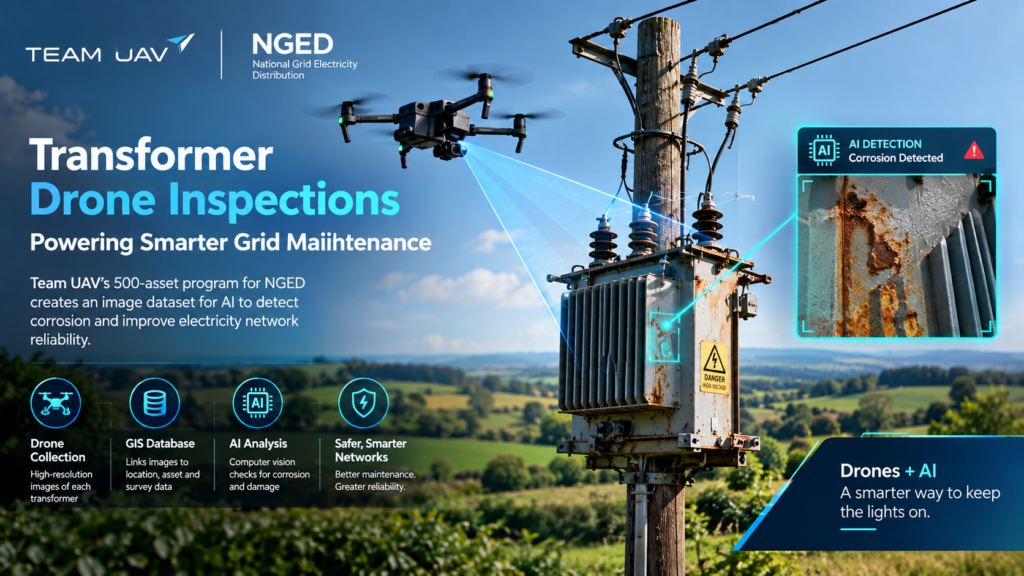
Utilities have always had a quiet problem: thousands of pole-mounted assets sit in fields, hedgerows and hillsides, and nobody can afford to send an engineer up every pole. Transformer drone inspections solve this by using unmanned aircraft to capture high-resolution images of each transformer, so that engineers and AI models can judge its condition from the ground. On 21 October 2026, UK drone services company Team UAV announced that it had finished 500 transformer drone inspections for National Grid Electricity Distribution (NGED), creating the image dataset for an AI project that tests whether corrosion can be spotted automatically.
This guide explains what happened, why the method matters, and what any utility, drone operator or technology team can learn from it. Each section is written to stand on its own, so you can jump straight to the part you need.
Quick facts at a glance:
- What: A drone inspection program covering 500 pole-mounted transformers
- Who: Team UAV (inspections), NGED (network owner), Softwire (AI and software)
- Where: Cornwall, Wales and the Midlands
- Why: To test whether computer vision can identify corrosion and other visible deterioration
- Funding: The Network Innovation Allowance (NIA)
- When: Announced 21 October 2026; initial project phase expected to finish by the end of 2026
What Are Transformer Drone Inspections?
Definition and expansion
Transformer drone inspections are visual surveys in which a drone flies around or above a transformer and captures photographs from planned positions, so the asset’s condition can be assessed without physical access. The images can be reviewed by a human engineer, processed by software, or both.
The expansion matters more than the definition. A single photograph is just a picture. What turns it into inspection data is a repeatable method: the same camera positions, the same capture technique, and a record that links every image to a specific asset, location and survey. Without that discipline, transformer drone inspections produce a folder of images that nobody can compare. With it, they produce a dataset.
Why pole-mounted transformers are a good target
Pole-mounted transformers are good candidates for drone inspection because they are numerous, spread across wide areas, and often difficult to reach. According to NGED innovation engineer Favour Eboh, these assets play a critical role in delivering electricity to homes and businesses, particularly in rural communities.
That combination creates a practical challenge. A distribution network operator may own an enormous number of such assets, scattered across farmland, woodland and steep terrain. Checking each one in person is slow. Checking them from the air, with consistent imagery, is a different proposition, which is exactly what this project set out to test.
The News: Team UAV’s 500-Transformer Program for NGED
Who is involved and what each party does
Three organisations share the work, and each has a distinct role. The split is a useful model for any similar program.
- Team UAV designed and delivered the inspection program, including the field work and the data delivery process. Founded in 2013, it is part of PDG Aviation Services.
- NGED owns and operates the local electricity network across the Midlands, South West England and South Wales. It is a distribution network operator, and it is separate from National Grid Electricity Transmission.
- Softwire, another NGED supplier, is developing the computer vision models and a prototype web application that will use the imagery to assess transformer condition.
Where and how the inspections ran
Team UAV worked from NGED’s national asset list and carried out the inspections across Cornwall, Wales and the Midlands. Those regions have very different landscapes, which is useful for a dataset meant to train AI. Imagery that only covers one type of terrain or lighting would be a weaker foundation than imagery gathered across varied conditions.
The program was funded through the Network Innovation Allowance, a mechanism used for innovation projects in the regulated energy sector. The funding detail is worth noting for readers outside the UK: this was an exploratory project, not a full rollout. NGED has said it will test the technology on an initial set of transformers and then assess its potential to support future network asset management.
How Did Team UAV Plan the Transformer Drone Inspections?
Team UAV planned the work in three stages: technical trials, a custom data system, and a fallback process for assets that could not be inspected. Each stage addresses a problem that tends to derail large inspection programs.
Technical trials before the main program
Before the full set of transformer drone inspections began, Team UAV ran trials to find the most suitable equipment, camera positions and capture techniques. The central aim was consistency, so that photographs from different sites would work well for AI analysis.
This is the step many teams skip. It is tempting to start flying and sort out the method later, but AI models are sensitive to variation. If one crew photographs a transformer from a high angle and another from the side, the model has to learn two different views of the same thing. Trials reduce that noise before it enters the dataset.
A custom GIS database and delivery process
Team UAV built a custom GIS database and delivery process for the project. Crews uploaded imagery from the field, and the system linked each set of images to an individual transformer location, together with survey information and metadata.
In plain terms, every photo could be traced back to a specific asset. That traceability is what lets an asset manager later ask a precise question, such as which transformers in a given area show surface deterioration, and get an answer tied to real locations.
Handling blocked or missing assets
Real networks are messy. Where access restrictions, vegetation or missing infrastructure prevented an inspection, the team identified suitable locations and alternative assets. That kept the program at its target of 500 transformers rather than leaving gaps in the dataset.
Why Does Consistent Imagery Matter for AI?
Consistent imagery matters because AI models learn from patterns, and inconsistent inputs make those patterns harder to find. A computer vision model trained on images with random angles, lighting and distances may confuse harmless variation with real signs of deterioration.
Mark DeGiovanni, technical lead at Team UAV, described the project’s focus as developing a consistent and repeatable approach, so that the imagery would be suitable for the next stage of AI analysis. That framing is the heart of the matter. The value of transformer drone inspections for AI does not come from the drone. It comes from the method that surrounds the drone.
Three properties make an inspection dataset useful to a model:
- Repeatability: the same capture method applied at every site
- Traceability: each image linked to one asset, location and survey record
- Coverage: enough variety in terrain, conditions and asset types to represent the real network
What Will Softwire’s Computer Vision Do With the Images?
Softwire will use the imagery to develop and test AI models and a prototype web application that assess transformer condition. The models are intended to identify visible signs of deterioration, including corrosion.
The ambition behind this is stated clearly by NGED: to explore whether aerial imagery, AI and computer vision can automate aspects of condition assessment, producing more consistent condition data to inform asset health reporting and investment decisions. Marcus Gardiner, client director for energy and utilities at Softwire, framed it as applying data science and engineering to complex real-world problems that affect the resilience of essential public infrastructure.
What AI asset condition assessment could change
AI asset condition assessment aims to replace subjective, inspector-by-inspector judgments with a consistent scoring approach. If it works, a utility could see its transformers ranked by visible condition, and direct maintenance money where it is most needed.
That outcome is still a hypothesis. The companies expect the initial phase of the wider project to finish by the end of 2026, and NGED has been careful to describe this as testing, not deployment. Readers should treat the AI results as pending until they are published.
Transformer Drone Inspections vs Traditional Inspection Methods
Drones do not replace every traditional method, but they change the economics of routine visual checks. The table below compares the two approaches on general criteria. It reflects common industry reasoning rather than figures from the NGED project, which has not published cost or time comparisons.
| Criterion | Transformer drone inspections | Traditional ground or climbing inspection |
|---|---|---|
| Access to hard-to-reach assets | Strong: aircraft can view assets from the air | Limited by terrain, vegetation and permissions |
| Consistency of data | High when capture method is standardised | Varies with the individual inspector |
| Suitability for AI analysis | Strong: images can be fed directly to models | Weak: notes and photos are often unstructured |
| Record keeping | Images linked to asset location and metadata | Depends on the process used |
| Close-contact checks | Limited to what a camera can see | Possible, including touch and testing |
| Best use | Routine visual condition surveys at scale | Detailed or specialist assessment of flagged assets |
The practical conclusion is a combination. Drone imagery can screen a large population of assets, and human specialists can then focus on the transformers that the screening flags.
The Capture–Link–Analyse–Decide Framework
The Capture–Link–Analyse–Decide framework is a four-step way to describe any AI-ready inspection program. It is our own summary of the pattern visible in the NGED project, not a term used by the companies involved.
- Capture: Fly a standardised pattern so that every image is comparable. In this project, trials set the equipment, camera positions and techniques.
- Link: Attach every image set to a specific asset, with survey information and metadata. In this project, a custom GIS database did this.
- Analyse: Apply computer vision to detect visible deterioration such as corrosion. This is Softwire’s role.
- Decide: Feed consistent condition data into asset health reporting and investment planning. This is NGED’s goal.
Most failed inspection programs break at step two. Teams capture good images but cannot connect them to assets, so the analysis and decision stages have nothing reliable to work with.
What Do Transformer Drone Inspections Mean for India?
For India, the NGED project is a useful template because it shows how to structure a pilot before scaling. India has a large and geographically varied power distribution network, and its utilities face the same basic problem of assets that are numerous and hard to check on foot.
Several points are worth drawing out for Indian students, freshers and young professionals:
- Skills are shifting toward data. The interesting work in this project is not only flying. It is the GIS, the metadata and the computer vision models.
- Pilots come before rollouts. NGED is testing on an initial set of transformers. A similar staged approach helps manage cost and risk.
- Regulation shapes feasibility. India’s Drone Rules, 2021 liberalised the framework for drone operations, but operators should always check current requirements before planning any survey.
- Local conditions matter. Monsoon weather, dense vegetation and varied terrain would all affect capture methods, which is why trials matter.
If you are building a career in AI, projects like this show where computer vision meets real infrastructure. The most valuable people sit between the field and the model.
What Are the Limits of Transformer Drone Inspections?
Transformer drone inspections can only report what a camera can see, so they detect visible deterioration but not hidden internal faults. The NGED project is explicitly about visible signs such as corrosion. It does not claim to measure internal condition, oil quality or electrical performance, and readers should not assume the method covers those.
Common mistakes that weaken a program
Three errors show up often in large inspection programs, and the NGED approach is designed to avoid each one.
- Starting to fly before the method is fixed. Without trials, crews improvise, and the dataset fills with incompatible views.
- Collecting images without asset links. A photo that cannot be tied to a specific transformer has little value for maintenance planning.
- Expecting AI to fix poor data. A model trained on inconsistent imagery will struggle, however advanced it is. Good input comes first.
When human inspectors still matter
Engineers remain essential. They interpret borderline cases, confirm what the AI flags, and carry out detailed checks that need physical access. The realistic goal of transformer drone inspections is to help specialists prioritise their time, not to remove them from the process. If NGED’s tests succeed, the likely result is a smarter queue of assets for human attention.
Checklist: Planning Your Own Transformer Drone Inspections Program
A good program starts with the dataset you want at the end, then works backward to the flying. Use this checklist as a starting point.
- Define what you want the AI or engineers to detect, such as corrosion or other visible deterioration
- Run technical trials to select equipment, camera positions and capture techniques
- Standardise the capture method so crews at different sites produce comparable images
- Build or choose a system that links each image set to one asset, location and metadata record
- Plan for access restrictions, vegetation and missing infrastructure, with alternative assets ready
- Cover varied regions and conditions so the dataset reflects the real network
- Keep a clear handoff between the drone team and the data science team
- Start with a limited pilot and review results before scaling
Frequently Asked Questions
What are transformer drone inspections?
Transformer drone inspections use drones to photograph transformers from planned positions so their condition can be assessed remotely. The images can support human review, AI analysis or both.
How many transformers did Team UAV inspect for NGED?
Team UAV captured high-resolution imagery of 500 pole-mounted transformers across the NGED network. The work covered Cornwall, Wales and the Midlands.
Why is NGED using drones and AI together?
NGED wants to test whether aerial imagery and computer vision can automate parts of condition assessment. The aim is more consistent condition data to inform asset health reporting and investment decisions.
Who is building the AI models?
Softwire, a fellow NGED supplier, is developing the computer vision models and a prototype web application. It will use the imagery from Team UAV’s inspections.
Does the project prove that AI can assess transformer condition?
No. The imagery has been collected, but the AI development and testing phase is still ahead. The companies expect the initial phase of the wider project to finish by the end of 2026.
What is the Network Innovation Allowance?
The Network Innovation Allowance (NIA) is the funding mechanism supporting this project. It is used for innovation work by network operators in the regulated energy sector.
Conclusion: The Method Is the Message
The headline number, 500 transformers, is impressive, but the lesson is in the method. Transformer drone inspections only become valuable for AI when capture is consistent, imagery is linked to individual assets, and a clear analysis stage follows. Team UAV’s trials, GIS database and fallback process for blocked assets all serve that goal.
Whether the AI models succeed will become clear after Softwire completes its work. Either way, the project offers a practical blueprint for anyone planning drone-based asset inspection.
Want to build skills in AI, computer vision and real-world data projects? Explore the training programs, workshops and explainers at Kalinga.ai to turn stories like this into career-ready skills.