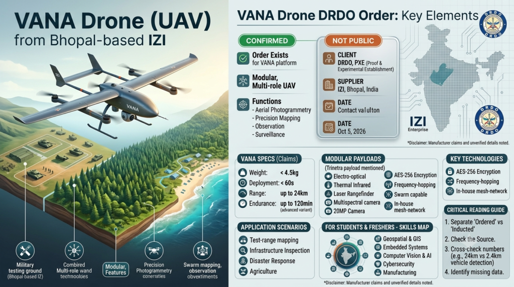
The VANA drone DRDO order is a purchase by DRDO’s Proof & Experimental Establishment (PXE) of the VANA surveillance drone from Bhopal-based IZI. According to Bots & Drones India’s summary of IZI’s 5 October 2026 announcement, the order covers an aerial photogrammetry platform for precision mapping, terrain and ground-feature data collection, aerial observation and surveillance. For students and young professionals, it is a useful case study in how an Indian startup moves from a consumer product to a defence-grade supplier.
If you follow India’s drone sector, this is the kind of story that looks small in a headline but says a lot about the industry’s direction. This guide explains what was ordered, who the players are, what the technical terms mean, and what remains unverified.
The Short Answer
DRDO is India’s main defence research agency. PXE is one of its test laboratories. IZI is a drone company that has recently pushed into industrial and defence markets through its IZI Enterprise arm. PXE has ordered IZI’s VANA drone for mapping and surveillance work.
Three points to keep in mind:
- What is confirmed: the order exists, it comes from DRDO’s PXE, and it is for the VANA platform, per the company announcement as summarised by Bots & Drones India.
- What is not public (in the sources I found): the rupee value, the number of units, the delivery schedule and the exact variant.
- Why it matters: it is a government validation signal for an indigenous drone, not a mass procurement. Treat it as an early milestone, not proof of large-scale adoption.
What Is the VANA Drone?
VANA is a modular, multi-role unmanned aerial vehicle (UAV) made by IZI. A UAV is simply an aircraft with no pilot on board, controlled remotely or by onboard autonomy. “Drone” is the everyday word for the same thing.
Specs Reported So Far
Most published figures come from the company itself, so read them as manufacturer claims rather than independently tested results.
- Weight and deployment: IZI’s launch coverage says VANA weighs under 4.5 kg and can be operational in under 60 seconds.
- Range and endurance: the same report cites a range of up to 24 km and endurance of up to 120 minutes in advanced variants.
- Sensing: The Week reports an infrared-enabled obstacle-sensing system covering forward, backward, left, right and downward directions. Its VANA Trinetra payload combines electro-optical, thermal infrared and laser rangefinder sensors.
- Cameras: the same report mentions a 20 MP camera for mapping and inspection, and a multispectral camera option on the VANA Pro.
- Security: AES-256 encrypted data links and frequency-hopping/direct-sequence spread-spectrum communication, aimed at reducing jamming and spoofing risk.
A discrepancy to note: The Week’s URL and one version of its headline mention spotting vehicles from “24 km”, while another version says “2.4 km”. I could not verify which is correct, so I have not used a vehicle-detection distance in this article. Always check the figure against the primary announcement before quoting it.
Modular Design: One Airframe, Many Jobs
Coverage of IZI’s defence announcement describes VANA as built around a common core platform rather than separate airframes for each role. The idea is that one base drone can be reconfigured with swappable payloads and communication systems for surveillance, mapping, inspection and other tasks.
For an operator, this matters because training, spares and maintenance can be standardised. A team learns one platform instead of several.
The Tethered Variant
The Week describes a tethered VANA demonstrated to the Indian Army. A tethered drone is physically connected to a ground station by a cable that supplies continuous power and data. The trade-off is simple: you gain long, steady hover time and a secure data link, but you lose free-roaming range.
Important caveat: Reports describe both a free-flying multi-role platform and a tethered system. I could not confirm which configuration PXE ordered. The order is described as an aerial photogrammetry platform, which usually implies a free-flying drone, but that is an inference, not a confirmed fact.
Who Is IZI, and What Is IZI Enterprise?
IZI is a Bhopal-based drone company. Per its defence announcement coverage, IZI Enterprise is its defence-first and industry-first arm, focused on standardised, configurable UAV systems for defence, the public sector, infrastructure and strategic industries.
Two supporting facts from the same coverage:
- IZI recently completed a ₹50 crore manufacturing expansion in Madhya Pradesh, with production capability for consumer and industrial UAVs.
- IZI says VANA supports swarm operations through an in-house mesh-network communication architecture. A swarm is a group of drones that coordinate with each other. This is a company claim and I did not find independent verification.
This matters because it shows a familiar path: a company builds credibility in consumer products, then uses manufacturing capacity and a modular platform to enter higher-value markets.
What Exactly Did DRDO’s PXE Order?
What Is PXE?
The Proof & Experimental Establishment (PXE) is a DRDO laboratory in the Armament and Combat Engineering Cluster. According to DRDO’s own document, PXE Chandipur (Balasore, Odisha) is engaged in dynamic test and evaluation of armament systems. In plain terms, it tests weapons and related systems under realistic conditions.
An aerial mapping and observation platform fits naturally into that world. Test ranges need accurate terrain data, and observation from the air helps teams see what happened during trials. That is my reasoning, not a stated purpose of the order, so treat it as context rather than fact.
What Is Aerial Photogrammetry?
Photogrammetry is the science of making measurements from photographs. A drone flies a planned pattern and captures many overlapping images. Software then stitches them into accurate maps, 3D models and elevation data.
Why it is useful:
- It turns images into measurable distances, areas and volumes.
- It is cheaper and faster than ground surveys for large or hard-to-reach terrain.
- It can be repeated over time to track changes.
What We Don’t Know
Based on the sources I could access, the following are not publicly confirmed:
| Detail | Status |
|---|---|
| Order value (₹) | Not disclosed |
| Number of drones | Not disclosed |
| Delivery timeline | Not disclosed |
| Exact VANA variant | Not disclosed |
| Whether it leads to larger procurement | Unknown |
If you write or share content on this topic, say so plainly. Filling these gaps with guesses is how misinformation spreads.
Why the VANA Drone DRDO Order Matters
Here is my analysis of why this VANA drone DRDO order deserves attention, even without a disclosed value.
1. It is a credibility signal. A defence laboratory choosing a startup’s platform tells other buyers that the product passed some level of scrutiny. That helps with future conversations, though it does not guarantee further orders.
2. It supports indigenisation. India’s policy push is toward domestically designed and built defence systems. A drone designed and manufactured in India, with local production capacity, fits that direction.
3. It sits alongside other Army interest. The Week reports that IZI demonstrated VANA to the Indian Army months after the Army issued a Request for Information (RFI) for 5,000 tethered drone systems. An RFI is an early step where a buyer asks industry what is available. It is not a purchase order.
4. It shows dual-use thinking. The same drone can map farmland, inspect infrastructure or support surveillance. Dual-use platforms can spread development costs across several markets.
Counterpoint worth stating: A single order, especially one with undisclosed size, is not the same as being inducted into service at scale. Evaluation orders are common in defence and do not always convert into larger contracts.
Comparison Table: Mapping Technologies
Photogrammetry is one of several ways to collect terrain data. This table is a general explanation of how the main methods differ, not specific to the PXE order.
| Feature | Drone Photogrammetry | Drone LiDAR | Satellite Imagery |
|---|---|---|---|
| How it works | Overlapping photos processed into maps and 3D models | Laser pulses measure distance to surfaces | Images captured from orbit |
| Typical strength | Detailed visual maps at low cost | Good at capturing ground under vegetation | Wide coverage, no flight needed |
| Typical limitation | Needs good light and visible ground | Sensor is usually costlier | Resolution and revisit timing depend on the satellite |
| Best for | Site mapping, inspection, change tracking | Terrain under tree cover, precise elevation | Regional monitoring |
| Flight planning needed | Yes | Yes | No |
The takeaway: no method wins everywhere. Photogrammetry is popular because cameras are affordable and the output is easy to interpret visually.
Comparison Table: Free-Flying vs Tethered Drones
This helps you understand the two VANA formats mentioned in reports.
| Feature | Free-Flying Drone | Tethered Drone |
|---|---|---|
| Power source | Onboard battery | Power via cable from ground |
| Flight time | Limited by battery | Can stay up for extended periods |
| Range | Wide, can travel across an area | Limited by cable length |
| Data link | Wireless | Wired, harder to intercept or jam |
| Typical use | Mapping, patrol, inspection | Fixed-point watch, event or perimeter monitoring |
Real-World Examples
These examples are illustrative scenarios showing how a platform like VANA could be used. They are not reports of what PXE is doing.
- Test-range mapping: A team flies a drone over a trial area before and after an event to compare terrain and ground features.
- Infrastructure inspection: A drone photographs a bridge or power line, and engineers inspect the images instead of climbing structures.
- Disaster response: After a flood, a drone maps affected areas quickly so relief teams can prioritise routes.
- Agriculture: A multispectral camera helps spot crop stress that is hard to see by eye. The VANA Pro is reported to support such a camera.
Career Angle for Students and Freshers
The IZI Enterprise VANA UAV story is also a map of skills the industry needs. If you are a student or early-career professional, these areas are worth exploring:
- Geospatial and GIS skills: processing drone imagery into maps (tools like QGIS are a free starting point).
- Embedded systems and avionics: flight controllers, sensors, communication links.
- Computer vision and AI: target tracking, obstacle detection, image analysis.
- Cybersecurity: encrypted links and anti-jamming matter in defence-grade systems.
- Manufacturing and quality engineering: scaling production reliably.
- Regulatory knowledge: understanding India’s drone rules and certification.
You do not need to work in defence to benefit. The same skills apply to agriculture, logistics, mining, surveying and infrastructure.
How to Read Defence Drone News Critically
Defence news is full of impressive-sounding specs. A few habits help:
- Separate “ordered” from “inducted.” An order, a trial and a service induction are three different things.
- Look for the source. Is the figure from the company, the buyer or an independent test?
- Check numbers across outlets. Even in this story, one headline had a 24 km versus 2.4 km discrepancy.
- Notice what is missing. Undisclosed value or quantity is itself information.
- Prefer primary sources such as company releases, ministry statements and stock-exchange filings, then use news articles for context.
FAQs
What is the VANA drone DRDO order?
It is an order placed by DRDO’s Proof & Experimental Establishment with Bhopal-based IZI for its VANA surveillance drone. Per Bots & Drones India’s summary of the company announcement dated 5 October 2026, the platform is intended for aerial photogrammetry, precision mapping and surveillance. The value and quantity have not been disclosed in the sources I found.
What is the VANA drone used for?
Per company-sourced coverage, VANA is a modular UAV for surveillance, mapping, infrastructure inspection, agriculture analysis and emergency response. Its swappable payload design lets one platform serve multiple roles. See the launch report.
What does PXE do?
PXE is a DRDO laboratory that, per DRDO’s own document, is engaged in dynamic test and evaluation of armament systems. It operates from Chandipur in Balasore, Odisha.
Is the VANA drone made in India?
IZI describes VANA as designed and manufactured in India, with production in Madhya Pradesh, and reports a ₹50 crore manufacturing expansion. These are company statements. I did not find an independent audit of the indigenous content percentage.
Does the DRDO order mean the Indian Army will buy VANA?
No. Those are separate developments. The Army reportedly received a VANA demonstration after issuing an RFI for 5,000 tethered drone systems, but an RFI is an information request, not a purchase commitment. The DRDO PXE order is a different matter.
What is a tethered drone, and is VANA tethered?
A tethered drone is connected to a ground station by a cable for continuous power and data. Reports describe a tethered VANA shown to the Army, while other coverage describes a free-flying modular platform. Which version PXE ordered has not been confirmed.
Conclusion
The VANA drone DRDO order is best read as an early but meaningful validation for an Indian startup moving into defence-grade UAVs. It shows demand for domestically built mapping and surveillance platforms, and it highlights a modular, multi-role design philosophy. It does not, on current public information, tell us the order’s size, the specific variant, or whether larger procurement will follow.
For readers building careers in this space, the practical lesson is to learn the underlying skills (geospatial analysis, embedded systems, AI vision, cybersecurity) and to read defence news with a careful eye for what is confirmed and what is claimed.